Kingsbridge residents and visitors will have a one day only opportunity of seeing a unique Tudor map of the town dating back to 1586.
Kingsbridge Cookworthy Museum will be open for the occasion between 10.30am and 3.30pm on Saturday, July 4 and there will be no entry charge on the day.
The map has been acquired by the South West Heritage Trust thanks to a grant of £17,691 from the Friends of the Nations’ Libraries.
It will be publicly accessible to researchers at the Devon Heritage Centre in Exeter.


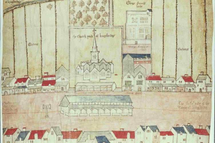
The map is known as the Kingsbridge Platt and is the oldest known map of the town.
It is a pen and ink drawing on vellum with a watercolour wash.
The main buildings of the time are shown including the 13th century parish church, the pillory and a timber-frame Market House called the ‘Chepe House’ where the manor court was held.
The map was made to show the properties owned by Sir John Petre, son of Sir William Petre who was Secretary of State to King Henry VIII, King Edward VI and Queen Mary.
Sir William was also on the Privy Council of Elizabeth I where he acted as deputy to Secretary of State Robert Cecil.
He managed to obscure his Catholicism serving on four Tudor courts.
Kingsbridge was part of the Devonshire estates which were acquired after the Dissolution of the Monasteries on the orders of King Henry VIII.
Sir William made a fortune out of the Dissolution as he bought his seat at Ingatestone Hall in Essex which was once owned by an abbey for a very low price.
Kingsbridge Museum Volunteer Nicola Fox said: “The map is truly unique and there was mystery surrounding it as it went missing between 1796 and the 1970s when it emerged in Guernsey.
“We’ve also been lent an 1835 map of the Manor of Dodbrooke so come down and take a look.”
Comments
This article has no comments yet. Be the first to leave a comment.